
U.S. States by Region: Official List of All 50 States
The United States has 50 states, and the cleanest way to organize them is by region. The official system used by the U.S. Census Bureau divides the country into four regions: Northeast, Midwest, South, and West. Those regions are then broken into nine smaller divisions.
This guide follows the official Census regions and divisions, not informal travel labels. That matters because names like New England, the Southwest, the Pacific Northwest, and the Deep South are useful, but they do not always match the official map. The Census Bureau’s regional map shows the four-region structure, while CDC/NCHS describes the same Census-based system as four geographic regions and nine divisions.
At a Glance: What Are the 4 U.S. Regions?
The four official U.S. regions are the Northeast, Midwest, South, and West.
| Region | Number of States |
|---|---|
| Northeast | 9 |
| Midwest | 12 |
| South | 16 |
| West | 13 |
Together, these four regions include all 50 states.
U.S. States by Region
| Region | States |
|---|---|
| Northeast | Connecticut, Maine, Massachusetts, New Hampshire, New Jersey, New York, Pennsylvania, Rhode Island, Vermont |
| Midwest | Illinois, Indiana, Iowa, Kansas, Michigan, Minnesota, Missouri, Nebraska, North Dakota, Ohio, South Dakota, Wisconsin |
| South | Alabama, Arkansas, Delaware, Florida, Georgia, Kentucky, Louisiana, Maryland, Mississippi, North Carolina, Oklahoma, South Carolina, Tennessee, Texas, Virginia, West Virginia |
| West | Alaska, Arizona, California, Colorado, Hawaii, Idaho, Montana, Nevada, New Mexico, Oregon, Utah, Washington, Wyoming |
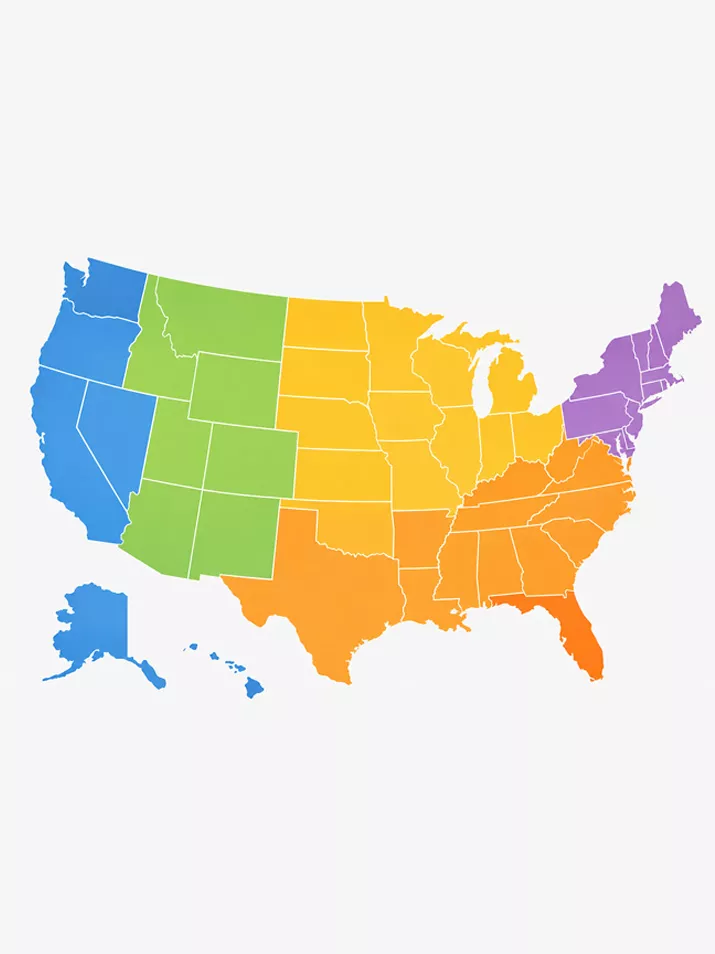
U.S. States by Region Map
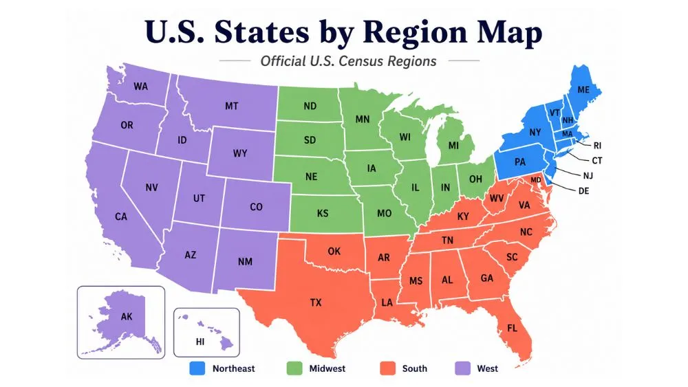
The U.S. Census Bureau groups the 50 states into four regions: Northeast, Midwest, South, and West.
Why Washington, D.C. and Puerto Rico Are Not in the 50-State List
Washington, D.C. and Puerto Rico are usually where the state-count confusion starts. D.C. appears in some statistical tables because it is the federal capital, but it is not a state. Puerto Rico appears in statehood conversations because it is a U.S. territory, but it is not a state either. USA.gov separates state and territory information in its government directory, which helps show the distinction.
That is why the regional list begins with 50 states, not 51 or 52. The confusion around 50 or 52 states starts when D.C. or Puerto Rico is counted incorrectly.
Once the count is settled, the 50 U.S. states can be grouped clearly into regions and divisions.
Official U.S. Regions vs Common Travel Regions
| Region Type | Examples | What It Helps Explain |
|---|---|---|
| Official Census regions | Northeast, Midwest, South, West | Where each state officially belongs |
| Census divisions | New England, Middle Atlantic, Mountain, Pacific | More detailed official grouping |
| Travel regions | Southwest, Pacific Northwest, Deep South | Road trips, scenery, weather, culture |
| Local or cultural regions | Appalachia, Lowcountry, Great Lakes | Smaller regional identity |
Official Census regions are built for consistent grouping. Travel regions are built around how people actually describe places.
That is why both can be useful. The Census map tells you where each state officially belongs. Travel names like Southwest, Pacific Northwest, Gulf Coast, Appalachia, and Great Lakes help explain landscape, culture, routes, and weather.
The simple rule is this: use Census regions for the official state list, then use travel regions when planning routes or describing a place more specifically.
Northeast Region States
| Division | States |
|---|---|
| New England | Connecticut, Maine, Massachusetts, New Hampshire, Rhode Island, Vermont |
| Middle Atlantic | New Jersey, New York, Pennsylvania |
The Northeast is compact. That is what makes it different from the larger regions. Several states sit close together, and many of the region’s major routes connect old cities, coastal towns, mountain areas, and historic corridors without requiring long cross-country distances.
New England is often treated like its own region in conversation, but officially, it is a Census division inside the Northeast. New York, New Jersey, and Pennsylvania form the Middle Atlantic division.
Midwest Region States
| Division | States |
|---|---|
| East North Central | Illinois, Indiana, Michigan, Ohio, Wisconsin |
| West North Central | Iowa, Kansas, Minnesota, Missouri, Nebraska, North Dakota, South Dakota |
The Midwest is not just “the middle.” Its eastern side is tied closely to the Great Lakes, while its western side opens into the Plains. That split is the reason Illinois and Michigan can feel very different from Nebraska or the Dakotas, even though they all belong to the same official region.
The East North Central division contains the Great Lakes-heavy states. The West North Central division contains the Plains-heavy states. That division is more useful than the broad “Midwest” label when you want to understand the region clearly.
South Region States
| Division | States |
|---|---|
| South Atlantic | Delaware, Florida, Georgia, Maryland, North Carolina, South Carolina, Virginia, West Virginia |
| East South Central | Alabama, Kentucky, Mississippi, Tennessee |
| West South Central | Arkansas, Louisiana, Oklahoma, Texas |
The South has the most states of any Census region, which is why it can feel too broad if you treat it as one single identity. Florida, Texas, West Virginia, Louisiana, and Tennessee all belong to the South, but they do not share the same landscape, climate, or travel pattern.
The three Census divisions make the region easier to read. The South Atlantic division reaches along much of the eastern side of the region. The East South Central group includes Alabama, Kentucky, Mississippi, and Tennessee. The West South Central includes Arkansas, Louisiana, Oklahoma, and Texas.
This is the clearest example of why official regions are useful but limited. They organize the map, but they do not replace names like Gulf Coast, Appalachia, Lowcountry, or Deep South.
West Region States
| Division | States |
|---|---|
| Mountain | Arizona, Colorado, Idaho, Montana, Nevada, New Mexico, Utah, Wyoming |
| Pacific | Alaska, California, Hawaii, Oregon, Washington |
The West has the widest range of any Census region because it combines two very different divisions: Mountain and Pacific.
The Mountain division is built around interior landscapes: deserts, plateaus, canyon country, ski states, high-elevation cities, beautiful mountains, and long-distance driving. Arizona is a clear example. It is officially part of the Mountain division, but that label alone does not explain its desert highways, canyon landscapes, Route 66 stops, red-rock towns, and winter sun. Those details give Arizona a clearer identity than the broader “West” label can.
The Pacific division works differently. California, Oregon, and Washington follow the Pacific Coast, while Alaska and Hawaii stretch the region far beyond the mainland. That is why the Pacific division can include rainforests, beaches, volcanoes, islands, glaciers, tech cities, wine regions, and some of the country’s longest coastal routes under one official label.
This is the main thing to remember about the West: the region is official, but its divisions do more of the explaining. “Mountain” tells you about the interior West. “Pacific” tells you about the coastal, island, and far-north West.
The 9 Official U.S. Census Divisions
The nine Census divisions give more detail than the four broad regions.
| Census Division | Region | States |
|---|---|---|
| New England | Northeast | Connecticut, Maine, Massachusetts, New Hampshire, Rhode Island, Vermont |
| Middle Atlantic | Northeast | New Jersey, New York, Pennsylvania |
| East North Central | Midwest | Illinois, Indiana, Michigan, Ohio, Wisconsin |
| West North Central | Midwest | Iowa, Kansas, Minnesota, Missouri, Nebraska, North Dakota, South Dakota |
| South Atlantic | South | Delaware, Florida, Georgia, Maryland, North Carolina, South Carolina, Virginia, West Virginia |
| East South Central | South | Alabama, Kentucky, Mississippi, Tennessee |
| West South Central | South | Arkansas, Louisiana, Oklahoma, Texas |
| Mountain | West | Arizona, Colorado, Idaho, Montana, Nevada, New Mexico, Utah, Wyoming |
| Pacific | West | Alaska, California, Hawaii, Oregon, Washington |
State-by-State Region Finder
Looking for one state only? Use this finder to check its official region and Census division.
| State | Region | Division |
|---|---|---|
| Alabama | South | East South Central |
| Alaska | West | Pacific |
| Arizona | West | Mountain |
| Arkansas | South | West South Central |
| California | West | Pacific |
| Colorado | West | Mountain |
| Connecticut | Northeast | New England |
| Delaware | South | South Atlantic |
| Florida | South | South Atlantic |
| Georgia | South | South Atlantic |
| Hawaii | West | Pacific |
| Idaho | West | Mountain |
| Illinois | Midwest | East North Central |
| Indiana | Midwest | East North Central |
| Iowa | Midwest | West North Central |
| Kansas | Midwest | West North Central |
| Kentucky | South | East South Central |
| Louisiana | South | West South Central |
| Maine | Northeast | New England |
| Maryland | South | South Atlantic |
| Massachusetts | Northeast | New England |
| Michigan | Midwest | East North Central |
| Minnesota | Midwest | West North Central |
| Mississippi | South | East South Central |
| Missouri | Midwest | West North Central |
| Montana | West | Mountain |
| Nebraska | Midwest | West North Central |
| Nevada | West | Mountain |
| New Hampshire | Northeast | New England |
| New Jersey | Northeast | Middle Atlantic |
| New Mexico | West | Mountain |
| New York | Northeast | Middle Atlantic |
| North Carolina | South | South Atlantic |
| North Dakota | Midwest | West North Central |
| Ohio | Midwest | East North Central |
| Oklahoma | South | West South Central |
| Oregon | West | Pacific |
| Pennsylvania | Northeast | Middle Atlantic |
| Rhode Island | Northeast | New England |
| South Carolina | South | South Atlantic |
| South Dakota | Midwest | West North Central |
| Tennessee | South | East South Central |
| Texas | South | West South Central |
| Utah | West | Mountain |
| Vermont | Northeast | New England |
| Virginia | South | South Atlantic |
| Washington | West | Pacific |
| West Virginia | South | South Atlantic |
| Wisconsin | Midwest | East North Central |
| Wyoming | West | Mountain |
Which U.S. Region Has the Most States?
The South has the most states. The Northeast has the fewest.
| Rank | Region | Number of States |
|---|---|---|
| 1 | South | 16 |
| 2 | West | 13 |
| 3 | Midwest | 12 |
| 4 | Northeast | 9 |
Using Regions for Travel Planning
Official regions help organize the map. Travel planning usually needs one more layer: what the region is actually useful for.
| Travel Goal | Region That Often Fits | Why |
|---|---|---|
| Early U.S. history and compact city routes | Northeast | States sit close together, and many routes connect older cities, coastal towns, and historic corridors. |
| Great Lakes, summer lake towns, and central road trips | Midwest | The eastern side connects to the Great Lakes, while the western side opens into plains, river towns, and longer drives. |
| Warm-weather cities, music routes, Gulf Coast, and Appalachian trips | South | The region is broad enough to include beaches, mountains, food cities, music hubs, and Gulf Coast routes. |
| National parks, deserts, mountains, Pacific coastline, Alaska, and Hawaii | West | The Mountain and Pacific divisions carry the country’s biggest range of landscapes and long-distance scenic routes. |
For travel planning, the official regions are only the first filter. The route usually becomes clearer when you narrow the map to America’s most beautiful states and then build around scenery, season, and distance.
FAQs About U.S. States by Region
The official U.S. Census system uses four regions: Northeast, Midwest, South, and West.
The four official regions are Northeast, Midwest, South, and West.
The Northeast has 9 states, the Midwest has 12 states, the South has 16 states, and the West has 13 states.
Texas is in the South region. It belongs to the West South Central division.
California is in the West region. It belongs to the Pacific division.
Florida is in the South region. It belongs to the South Atlantic division.
New York is in the Northeast region. It belongs to the Middle Atlantic division.
Hawaii is in the West region. It belongs to the Pacific division.
Alaska is in the West region. It belongs to the Pacific division.
No. Washington, D.C. is a federal district, not a state.
There are 50 states in the USA. Washington, D.C. and Puerto Rico are not states.
New England is not one of the four main Census regions. It is an official Census division within the Northeast region.
No. The Southwest is a common travel and cultural region, not one of the four official Census regions.
The South comes first, with 16 states in the official Census grouping.
Final Takeaway
The U.S. region map is easiest to understand in layers. Start with the four official Census regions: Northeast, Midwest, South, and West. Use the nine divisions when you need a closer look at where states fit. Then use names like New England, the Southwest, or the Pacific Northwest when you are talking about culture, scenery, weather, or travel routes.
In other words, the official map gives you the structure; regional names give you the local meaning.
Sources
U.S. Census Bureau regional map: https://www2.census.gov/geo/pdfs/maps-data/maps/reference/us_regdiv.pdf
CDC/NCHS explanation of U.S. Census geographic regions and divisions: https://www.cdc.gov/nchs/hus/sources-definitions/geographic-region.htm
USA.gov state and territory government directory: https://www.usa.gov/state-governments