

48 Contiguous States: Complete List, Map and Meaning
The 48 contiguous states are the U.S. states connected across the North American mainland. They include every state except Alaska and Hawaii.
Together, they stretch from Maine’s rocky Atlantic coast to the Pacific shores of California and Washington. Between those distant edges lie the Great Lakes, the Great Plains, the Rocky Mountains, desert country, and more landscapes than a single road trip could reasonably cover.
You may have heard this part of America called the Lower 48. It’s a familiar expression, especially in travel and geography, but there is a distinction worth knowing: the contiguous United States and the continental United States are not always the same thing.
At a Glance: The 48 Contiguous States
| Question | Answer |
|---|---|
| How many contiguous states are there? | 48 |
| How many U.S. states are there altogether? | 50 |
| Which states are excluded? | Alaska and Hawaii |
| What is another name for the 48 contiguous states? | The Lower 48 |
| Is Washington, D.C. one of the 48 states? | No. It is a federal district. |
| Is Alaska part of continental North America? | Yes |
| How many Census regions contain the 48 states? | Four: Northeast, Midwest, South, and West |
The difference between 48 and 50 is entirely geographic. Alaska and Hawaii are full U.S. states, just like California or Maine. They simply sit outside the connected mainland group.
For the complete national count, including Alaska and Hawaii, our guide to how many states are in the U.S. explains how the country reached its present 50-state map.
What Are the 48 Contiguous States?
The word contiguous describes places that touch or connect along their boundaries.
Applied to the United States, it refers to the 48 states that form a continuous geographic group between Canada and Mexico, bordered by the Atlantic and Pacific oceans.
Picture a journey beginning in Oregon and ending in Florida. You could travel through one U.S. state after another without crossing into another country. That’s the idea behind the contiguous states: they form one connected block, even though their climates, scenery, and cultures are wonderfully different.
The U.S. Geological Survey uses the formal term conterminous United States for the 48-state block together with Washington, D.C. It also recognizes that contiguous is the more familiar everyday expression.
One small distinction matters here. When we say 48 contiguous states, we are counting states, not every separate piece of land within them. Coastal islands belonging to Florida or other mainland states do not change which states belong to the group.
Complete List of the 48 Contiguous States
Here are all 48 contiguous U.S. states in alphabetical order, along with their official Census regions.
The state names follow the U.S. Census Bureau’s geographic code references, and the regions follow its established four-region classification.
| No. | State | Region |
|---|---|---|
| 1 | Alabama | South |
| 2 | Arizona | West |
| 3 | Arkansas | South |
| 4 | California | West |
| 5 | Colorado | West |
| 6 | Connecticut | Northeast |
| 7 | Delaware | South |
| 8 | Florida | South |
| 9 | Georgia | South |
| 10 | Idaho | West |
| 11 | Illinois | Midwest |
| 12 | Indiana | Midwest |
| 13 | Iowa | Midwest |
| 14 | Kansas | Midwest |
| 15 | Kentucky | South |
| 16 | Louisiana | South |
| 17 | Maine | Northeast |
| 18 | Maryland | South |
| 19 | Massachusetts | Northeast |
| 20 | Michigan | Midwest |
| 21 | Minnesota | Midwest |
| 22 | Mississippi | South |
| 23 | Missouri | Midwest |
| 24 | Montana | West |
| 25 | Nebraska | Midwest |
| 26 | Nevada | West |
| 27 | New Hampshire | Northeast |
| 28 | New Jersey | Northeast |
| 29 | New Mexico | West |
| 30 | New York | Northeast |
| 31 | North Carolina | South |
| 32 | North Dakota | Midwest |
| 33 | Ohio | Midwest |
| 34 | Oklahoma | South |
| 35 | Oregon | West |
| 36 | Pennsylvania | Northeast |
| 37 | Rhode Island | Northeast |
| 38 | South Carolina | South |
| 39 | South Dakota | Midwest |
| 40 | Tennessee | South |
| 41 | Texas | South |
| 42 | Utah | West |
| 43 | Vermont | Northeast |
| 44 | Virginia | South |
| 45 | Washington | West |
| 46 | West Virginia | South |
| 47 | Wisconsin | Midwest |
| 48 | Wyoming | West |
Notice that Texas and Oklahoma are listed under the South. Although both are often associated with the Southwest in travel writing, the Census Bureau places them in its West South Central division, which belongs to the South region.
For a closer look at these official boundaries, WLC’s U.S. states by region guide explains how the four regions and nine Census divisions fit together.
How We Curate This Guide
Shanzaib Haider, Senior Editor at Wanderlust Craze, reviewed this guide to explain the 48 contiguous states and clear up common confusion about Alaska, Hawaii, Washington, D.C., and the Lower 48.
The state list and regional groupings were checked against U.S. Census Bureau references, while geographic definitions were cross-checked with the U.S. Geological Survey.
Map of the 48 Contiguous United States
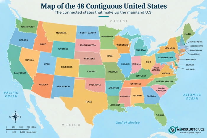
Look at a map of the Lower 48 and you’ll see one broad stretch of the country, from the wooded Northeast and Great Lakes to the mountain ranges, deserts, and coastlines of the West.
The map also makes the relationship between states easier to understand. Tiny Rhode Island and enormous Texas look nothing alike, yet both belong to the same connected group.
Alaska and Hawaii are often placed in separate inset boxes on maps showing all 50 states. Those boxes are a convenient way to fit the country onto one page; they don’t show the states’ actual positions relative to the mainland.
And while the outline of the Lower 48 may be familiar, what lies inside it is remarkably varied. Maine’s granite coastline, Nevada’s mountain basins, Kentucky’s forested hills, and New Mexico’s desert landscapes all belong to the same map. That variety is part of what makes comparing the most beautiful states in the USA so interesting.
Which Two States Are Not Part of the 48 Contiguous States?
The two states excluded from the contiguous United States are Alaska and Hawaii. Neither shares a border with the connected 48-state block.
Alaska
Alaska is the northernmost U.S. state, stretching across an extraordinary expanse of mountains, glaciers, tundra, forests, and coastline.
Although Alaska is part of North America, Canada separates it from the other U.S. states. That is why it is not counted among the Lower 48.
This geographic separation matters when you’re planning a road trip. To drive to Alaska from the mainland United States, travelers normally pass through Canada, following routes such as the Alaska Highway.
Travel Alaska’s official driving guide explains the routes through British Columbia and the Yukon, along with practical considerations for the journey.
Here’s the distinction to remember: Alaska is continental, but it is not contiguous with the other 48 states.
Hawaii
Hawaii presents a different picture altogether.
Located in the Pacific Ocean, Hawaii is made up of islands rather than territory attached to the North American mainland. Its volcanoes, lush valleys, beaches, and tropical landscapes feel far removed from the long highways and broad plains of the Lower 48.
Hawaii is neither part of the contiguous United States nor part of continental North America.
That does not make it any less American. Hawaii became the 50th state in 1959 and remains an essential part of the country’s geography, culture, and history.
Contiguous vs. Continental vs. Conterminous United States
These four expressions can sound as though they mean exactly the same thing. In everyday conversation, people sometimes use them that way.
Official geographic definitions are more precise.
| Term | Meaning | Alaska Included? | Hawaii Included? |
|---|---|---|---|
| 48 contiguous states | The 48 connected mainland states | No | No |
| Lower 48 | Informal name for the same 48 states | No | No |
| Conterminous United States | The 48-state block and Washington, D.C., under USGS definitions | No | No |
| Continental United States | The 49 states on North America, plus Washington, D.C., under USGS definitions | Yes | No |
According to the U.S. Geological Survey’s official geographic definitions, the continental United States includes Alaska because Alaska lies on the North American continent. The conterminous United States, by contrast, refers to the connected 48-state area and Washington, D.C.
That distinction is particularly useful when reading geographic reports or comparing maps. Some organizations use continental U.S. more loosely to mean the Lower 48, so the intended definition still matters.
For ordinary travel conversation, Lower 48 is often the clearest way to describe the connected mainland states without including Alaska or Hawaii.
Are Washington, D.C. and U.S. Territories Included?
Washington, D.C. sits inside the geographic area of the contiguous United States, between Maryland and Virginia. But it is a federal district, not one of the 48 states.
This explains why some official definitions of the conterminous United States include D.C., while a list of the 48 contiguous states does not.
U.S. territories are also excluded. Puerto Rico, Guam, the U.S. Virgin Islands, American Samoa, and the Northern Mariana Islands are not U.S. states. Their governments and legal status are different from those of the 50 states.
The official USA.gov state and territory directory provides a reference for these distinctions.
The same confusion sometimes leads people to ask whether America has 50 or 52 states. The answer remains 50; neither Washington, D.C. nor Puerto Rico adds another state to the count.
How Are the 48 Contiguous States Divided by Region?
The U.S. Census Bureau groups the states into four broad geographic regions. Remove Alaska and Hawaii from the West, and the 48 contiguous states are distributed as follows:
| Census Region | Contiguous States |
|---|---|
| Northeast | 9 |
| Midwest | 12 |
| South | 16 |
| West | 11 |
| Total | 48 |
These numbers follow the official Census regional classification.
The Northeast contains New England and the Middle Atlantic states, with historic cities, busy corridors, and relatively short distances between many destinations.
The Midwest stretches across Great Lakes country and the central plains. Its landscapes range from Michigan’s lake shores to the open grasslands of the Dakotas.
The South is the largest region by number of states. It reaches from Delaware and Virginia through the Southeast to Texas and Oklahoma, embracing an enormous variety of climates and cultural traditions.
The contiguous West includes the Pacific Coast states of Washington, Oregon, and California, along with eight Mountain states. It is a land of desert plateaus, alpine ranges, rugged coastal scenery, and long driving distances.
These official regions provide a helpful starting point, although a traveler’s idea of the Southwest, Appalachia, or the Pacific Northwest may cross regional boundaries.
Why Do People Call Them the Lower 48?
The expression Lower 48 is an informal way of describing the contiguous states, especially when distinguishing them from Alaska.
You’ll encounter it in Alaskan travel information, road-trip discussions, and descriptions of journeys between Alaska and the rest of the United States.
It is not suggesting that the 48 states are all at a lower elevation. The name is associated with their geographic position south of Alaska.
A traveler setting out from Washington state toward Alaska, for example, is leaving the Lower 48. The route north leads through Canada before reaching Alaska.
The phrase is so familiar that Alaska’s official tourism resources use it themselves when discussing the journey north.
What Do the 48 Contiguous States Mean for Travelers?
The great advantage of the contiguous states is their connection. You can travel between all 48 states by road without needing to cross an international border.
That does not mean every journey is short or easy. Driving from the forests of New England to the California coast still means crossing thousands of miles and several distinct landscapes.
Travel to Alaska or Hawaii involves a different kind of planning. Driving to Alaska ordinarily takes you through Canada, while reaching Hawaii from the mainland requires air or sea travel.
The geography is also a reminder of how much of the country a familiar mainland map leaves out.
The U.S. has 50 states altogether, not 48. The Lower 48 are simply the connected portion. For a complete A–Z reference that includes Alaska and Hawaii, the 50 states and capitals list shows the full national picture.
Frequently Asked Questions
The 48 contiguous states are the U.S. states that form a connected geographic block on the North American mainland. They include all U.S. states except Alaska and Hawaii.
Alaska and Hawaii are the two states excluded from the contiguous United States. Alaska is separated from the Lower 48 by Canada, while Hawaii consists of islands in the Pacific Ocean.
Yes. Under U.S. Geological Survey definitions, Alaska is part of the continental United States because it is located on the North American continent. It is not part of the contiguous United States.
No. Hawaii is located in the Pacific Ocean and is not part of continental North America or the 48 contiguous states.
Yes. The Lower 48 is a common informal name for the 48 contiguous U.S. states.
No. Washington, D.C. is geographically within the conterminous U.S. area, but it is a federal district rather than a state, so it is not counted among the 48 states.
No. Puerto Rico is a U.S. territory in the Caribbean. It is not one of the 50 states and is not part of the Lower 48.
Yes. All 48 states are connected within the mainland U.S. road network, making it possible to visit each state by car without crossing into Canada or Mexico.